Storm Water Best Management Practices (BMP) Plan for Four Major Outlets at Ka‘elepulu Pond
|
Download the Entire BMP Plan (Pages 1-286, 47MB pdf) |
|---|
Prepared for the City and County of Honolulu, Department of Environmental Services
Nov 2008
EXECUTIVE SUMMARY
This storm water best management practices (BMPs) plan is prepared for the City and County of Honolulu (City), Department of Environmental Services (ENV) and evaluates four major outlets, as defined in 40 CFR Part 123 Subpart B, and their corresponding drainage areas.
The major outlets are associated with the Windward District in the Kailua Watershed and discharge into Kaelepulu Pond (ID# WKIP). The outlets were chosen for this study after field reconnaissance and Enchanted Lake Resident Association (ELRA) interviews and were identified as major contributors of sediment and gross pollutants into Kaelepulu Pond. The original scope of the project included analysis and evaluation of potential structural and non-structural improvements at the outfalls and drainage areas associated with WKIP 14 and 52. A July 2007 modification (MOD) to the Scope of Work (SOW) included additional and equal analysis and evaluation for WKIP 10 and WKIP 44.
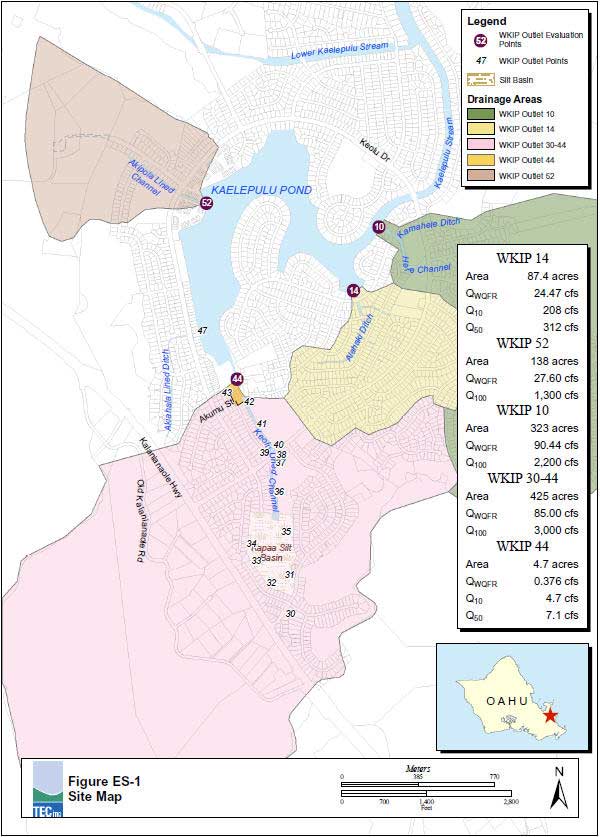
The following general tasks were evaluated for each drainage area (Figure ES-1): 1) Field survey identifying pollutant sources; 2) Overview of drainage area; 3) Develop BMPs Plan for two commercial facilities associated with WKIP 10; 4) Develop BMPs Plan for structural (and non-structural) improvements, including maintenance issues and suggestions for improvements based on field observations; and 5) sediment sampling and testing for 3 of the 4 outlets associated with the drainage basins and a composite sample within the WKIP 10 Hele Channel near the proposed structural BMP site.
The main intent of this storm water BMPs Plan is to address complaints of sediment build up and odors at Kaelepulu Pond through structural (and non-structural) BMPs. Additionally, this report attempts to address gross pollutant issues that were discovered through field investigation and resident interviews for the drainage areas. Specific tasks are identified in Section 1.2.5.
The Rules Relating to Storm Drainage Standards (RRSDS) (City 2000) was used to complete two separate hydrological analyses of the four WKIP outfalls (WKIP 14, WKIP 52, WKIP 10, and WKIP 44; [plus the WKIP 44 outfall accumulative drainage area, see section 1.3.4], here after referred to as WKIP 30-44) into Kaelepulu Pond (see also Section 3). Each drainage area outlet was examined for peak storm drainage flows expected from rainfall intensities of storm events with recurrence intervals of 10 and 50 years for WKIP 14 and WKIP 44; and 100 years for WKIP 52, WKIP 10, and WKIP 30-44 as required for drainage areas greater than 100 acres. Additionally, the volume of storm water generated and diverted to each drainage outlet during the initial flush of a storm is also addressed. The first flush condition, as expected, was found to be significantly less than the peak flows for 10-, 50-, and 100-year storm event of each of these major open-channel outlets. Therefore, the design for any structural BMP should take into account the ability to convey peak discharge flows during major storm event, along with full treatment of storm water quality flow rates (QWQFR) generated during the initial flush.
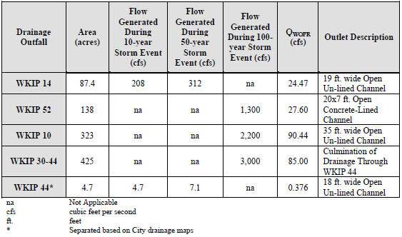
Table ES-1 summarizes the four outlets and respective drainage areas in this study.

Table ES-1. Kaelepulu Pond Outlet Summary
A summary of hydrological analysis, literature search, recommendations and conclusions were completed at the end of each section to help the City select the appropriate structural BMP devices for each of the drainage areas. A literature search was performed to review the latest available BMPs for treatment of discharged urban storm water. An overall storm water management strategy, with suitable treatment for the open channels, associated with WKIP 14, 52, 10, and 44 drainage areas was developed based on the following criteria:
- Review applicable non-structural BMPs to remove sediment from the WKIP 14, 52, 10 and 44 storm water conveyance system, decreasing sediment input into Kaelepulu Pond;
- Review and analysis of commercially available structural BMPs presented in Section 4 to remove sediment from the WKIP 14, 52, 10, and 44 storm water conveyance system, decreasing sediment input into Kaelepulu Pond; and
- Hydrological and physical characteristics of the four drainage areas discussed. Due to the urbanization of the four drainage areas and lack of space for BMP installation, BMP associated with storm water storage and reuse was not feasible. There are numerous commercial hydrodynamic separator options for storm water treatment in areas with limited space.
The overall peak runoff discharge rate for WKIP 14, 52, 10, and 44 drainage areas are very high at the drainage channel outlets and upstream portions of the open channel. Individual storm flows from the multitude lateral pipe connections discharging into the open channels associated studies drainage area have manageable flow rates but were ruled out as potential locations for inline placement of BMPs for the following reasons: 1. Lack of right-of-way for installation; 2. Lack of City maintenance access easements; and 3. Any potential installation at a select location(s) would offer only minimal pollution prevention treatment benefits due to the sheer number of these “lower flow” connections.
The major factors driving the selection and design of the storm water management strategy or treatment train for each drainage area and site specific recommendations of non-structural and/or placement of structural BMP treatment options is:
1). the achievement goal of up to 80% TSS removal as stipulated by Rules Relating to Storm Drainage Standards (City 2000) – a requirement only if DPP permits are required for installation (i.e. grading permits etc.);
2) the capability of conveying peak runoff flows produced during major storm events; and
3) installation and maintenance crew accessibility to the structural BMP.
The primary function of this storm water strategy is to improve storm water discharge quality into Kaelepulu Pond. In order to achieve this goal a combination of BMPs, non-structural and structural, were selected for each drainage area based on current practices. Structural BMPs that were recommended and installation locations were based on: locations of maintenance access easements, “hot spots” or high pollutant areas, storm water flow rates, location of tail waters, water quality treatment flow rates, sediment removal efficiencies, and overall cost of the BMP device including installation and operations and management (O&M).
The recommendations for each drainage area includes a Hydrothane Systems, Inc. Trash Tack to be installed near the outlet and last serviceable location of each of the drainage areas to capture gross pollutants (i.e. floatable debris [green waste and trash]) before it enters Kaelepulu Pond. Additional options include installing Bio Clean curb inlet baskets with shelf system to treat the street runoff into the system, and Bio Clean grate inlet skimmer boxes to treat the Enchanted Lake Shopping Center (ELSC) parking lot run off (see Section 5 figures and Appendix A respectively).
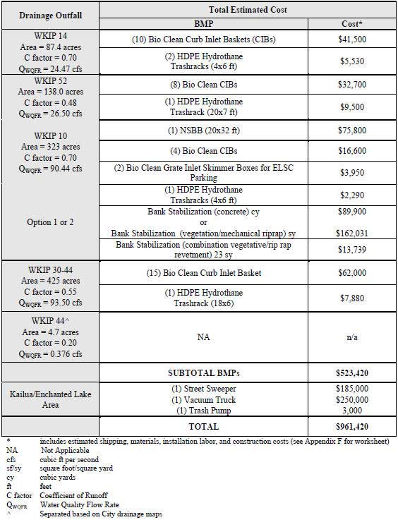
Since the open channels are conveying the majority of the flow (and pollutants), compared to the lateral in-line pipe systems, they became the focus areas for a structural BMP approach. Considering the lack of tested structural BMPs for an open-system this size, it is recommended that a pilot project be initiated utilizing the Suntree Technology, Inc. Bio Clean Nutrient Separating Baffle Box (NSBB) for the WKIP 10 Hele concrete-lined channel. The NSBB effectively separates organics and litter from sediments and standing water preventing organic leaching and the possibility of the system going septic. Additionally, there are areas within Hele Channel that need wall rehabilitation, and areas downstream in the natural portions of the channel which require bank stabilization to eliminate erosion. Structural BMP recommendations and estimated costs for each drainage area are summarized below and in Table ES-2:
- At WKIP 10, a pilot project utilizing a Bio Clean NSBB within the 20-foot Hele concrete open-channel. A conceptual design will need to be developed to assess the specific location and potential hydraulic impacts on the channel. The anticipated location will be just west of the Keolu Drive Bridge (Figure 5-3), within serviceable used to service this BMP. The drainage area upstream of this location is approximately 260 acres (calculated using GIS) with a flow rate of over 700 cfs based on City drainage reports. The QWQFR is approximately 70 cfs. It is anticipated that the NSBB hydrodynamic separator will be cast-in-place below channel grade and within the City right-of-way.
- Bio Clean curb inlet baskets with shelf system are recommended for installation at all four drainage areas. Two Bio Clean grate inlet skimmer box installations are recommended within the ELSC parking area (Figures 5-1 through Figures 5-4). Prior to installation it is recommended that existing debris be removed from the catch basins. A street sweeping/catch basin cleaning program should be established within the drainage areas for full BMP effectiveness.
- As a final measure to prevent gross pollutant discharge into Kaelepulu Pond, a Hydrothane Systems, Inc. trash rack are recommended for installation in all four drainage areas near the outlets and/or City maintenance access areas (see Figures 5-1 through Figures 5-4). The Hydrothane trash rack is made of High Density Polyethylene (HDPE) which provides “end-of-system” containment of floating debris. Specific trash rack angles and blade spacings will be determined, but will be approximately a 10-15 degree angle with 4 to 8-inch blade spacing: o Within the WKIP 14 and 10 drainage areas, the trash racks will be positioned in the downstream portions of the channel, on the upstream side of bridge culverts (Figures 5-1 and 5-3) ;
- Within the WKIP 52 and 44 drainage areas, the trash racks will be positioned within the concrete-lined channel near the outlets (Figures 5-2 and 5-4).
- As a measure to prevent erosion along the banks of the WKIP 10 drainage area two bank stabilization projects are recommended:
- Approximately 500 feet of either vegetative and/or mechanical riprap revetment, or concrete revetment, within the Hele Channel is recommended downstream from the NSBB pilot project (Figure 5-3). The concrete revetment designed would match existing sections of concrete bank stabilization in this area of the channel;
- Approximately 50 feet (on each side) of vegetative and/or mechanical riprap revetment located within the Kamahele Ditch is recommended just downstream from the Keolu Drive Bridge (Figure 5-3). A combination of deposited sediment removal blocking the pipe culvert and protection of bank and root system in this ditch is required (Photos 1-21 and 1-22).
Table ES- 2. Kaelepulu Pond Storm Water Management Strategy Cost Summary


Download the Entire BMP Plan (Pages 1-286, 47MB pdf)
Download Chapters 1-6 (Pages 1-146, 16MB pdf)
Download Appendices (Pages 147-286, 32MB pdf)