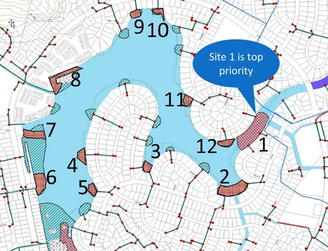
The ELRA board is working on permits for the dredging of portions of the lake to improve water circulation, restore aquatic habitat, and re-establish the navigable waterway capacity for public health, safety, and enjoyment. The project would involve dredging up to 23,900 cubic yards of silt, clay, gravel, and aquatic vegetation from locations within Ka‘elepulu Pond.
Map of Dredge Locations

Site 1 is the shallow area of the canal just mauka of the Keolu Bridge and, given the costs for engineering and permitting, it is likely to be the only site dredged. The plan is to cut a 50ft wide channel approximately 8ft deep to facilitate greater salt water exchange into the main body of the estuary when the stream mouth is open to the ocean. This will result in an increase in salinity and increased circulation which will reduce fresh water algae growth, allow the oyster population to re-bound, and is expected to support a healthier estuary ecosystem.
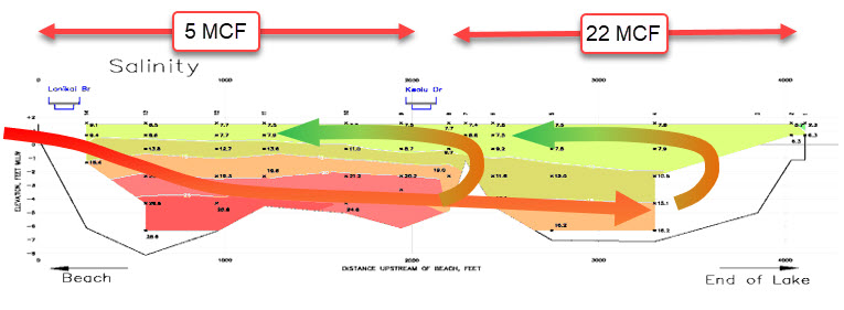
Cross section of lake: Current conditions
This cross section of the Kaelepulu Stream and Pond from the beach (left), past the shallow sill (center) through the pond and to the Kaelepulu Wetland (right) shows how the shallow sill restricts salt water exchange.

Cross section of lake: After dredging at Site 1
Removal of the shallow sill would allow the inflowing salt water to mix with the entire volume of the estuary – not just the volume of the canal.
