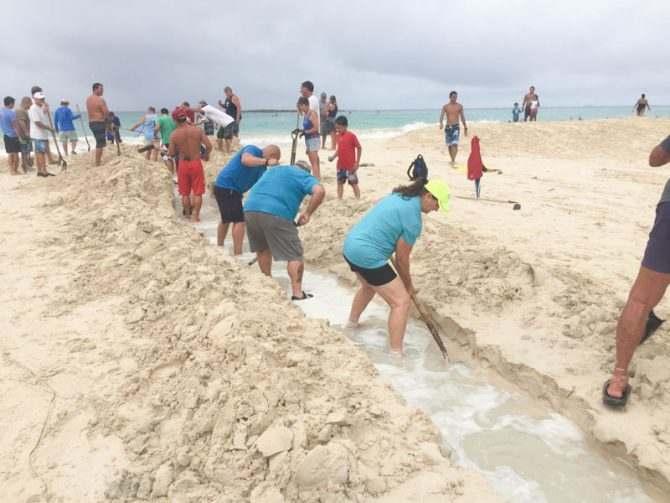
The dig party on Sunday (7/31) started at 3 PM and really finished about 4 PM, but we wanted to wait until 4:30 to open at the ocean so that the tide had time to drop a bit further. We kept it closed at the end right next to the ocean. During the extra half hour while we were waiting to open the ocean end, folks widened the channel a little but that was really unnecessary. It was mostly because we had the extra time. We opened it at 4:30.
The last pictures of the dig on Sunday evening show the water slowly starting to move down the new channel at that time.
The next set of photos shows what the channel was like at 6:30 AM the next morning (Monday 8/1). During the night with the low tide allowed the lake water to cut a very strong channel in the sand as it escaped to the ocean. Having the lake at 2+ ft above average ocean height probably helped a lot in making the channel so pronounced as large amounts of water flowed to the ocean.
The third batch shows what the channel looked like at around 6 PM in the evening (Monday 8/1). This is now a little more than 24 hrs after we opened the channel. The channel has moved to its natural location on the other side of the stream bed. With the tide changes during the day and water from the ocean washing back up during the high tide, there is evidence of a wide bed that probably existed when the water flowed slowly during the tide change. All together these pictures show the power of having even just a very small channel opened at just the right time.
Scroll down to see photos and video. Click on the photos to see them larger.
Sunday afternoon – Stream Opening


Monday morning – Stream after flowing just through the night


Monday evening – Stream after about 24 hours open


Click to view all photos…
The scientific summary of the opening
July 31, 2016 at about 3PM approximately 60 people participated in digging a narrow 2-foot wide, 150-foot long channel through the Kailua Beach sandbar blocking flow at the mouth of the Kaelepulu Stream. The stream was at elevation 2.75 MLLW, or about 0.5 foot below flood stage. Flow was initiated about 430 pm. By 10pm the channel had widened itself to an estimated 8 feet and by 8am August 1 the channel was 24 feet wide and over 2 feet in depth flowing out at about 3 feet per second. The sand eroded from the channel by the stream and re-deposited into the beach system is estimated to be (8yd*0.75yd*50yd) 300 cu yd. Overnight rainfall was about 1.5 inch and likely helped to sustain and open the stream to full flow. Typically a 1.5 inch rainfall would result in an elevation rise of 4.5 inches in the lake.
The stream stayed open to full flow for about three days, and to minor flows for an additional 2 days. The graphic below plots measured water surface elevations and extrapolated trends over time superimposed on the predicted Waimanalo tides. Total outflow from the 142 acre system as measured from the graphic is (1.37+0.9+0.4+0.2=2.87 ft*142 ac) 17.75 million cubic feet (MCF) of primarily fresh and brackish water flowing out of the system. Inflow from the ocean, primarily 33ppt seawater, was about (.2+.6+.5+.4+.2+.2 = 2.1 ft*142 ac) 13 MCF. Final elevation of the lake at closing was 1.56 ft MLLW. Given an estimated volume of the entire Kailua Waterways System of 26.5 MCF, this exchange was significant and will likely have a positive impact upon water quality and ecosystem functions within the system.
